
![]() The WIND projet aims to develop seismic imaging methods which are more specifically devoted to stationary-recording acquisitions involving sparse arrays of autonomous stations (ocean bottom seismometers or land stations). The fact that the receiver layout is fixed gives the necessary versatility to design acquisition geometries involving large source-receiver offsets and wide azimuths such that waves can interact with subsurface heterogeneities in a varied manner by trasmission, reflection and diffraction. The rich angular illumination of the subsurface resulting from these acquisition geometries provides a suitable framework for high-resolution multi-parameter imaging provided the imaging techniques manage to assimilate the information content of the seismic data. In this context, we develop the so-called Full Waveform Inversion (FWI) method that aims to reconstruct the subsurface properties with a wavelength resolution by minimizing a distance between the recorded and the simulated data.
The WIND projet aims to develop seismic imaging methods which are more specifically devoted to stationary-recording acquisitions involving sparse arrays of autonomous stations (ocean bottom seismometers or land stations). The fact that the receiver layout is fixed gives the necessary versatility to design acquisition geometries involving large source-receiver offsets and wide azimuths such that waves can interact with subsurface heterogeneities in a varied manner by trasmission, reflection and diffraction. The rich angular illumination of the subsurface resulting from these acquisition geometries provides a suitable framework for high-resolution multi-parameter imaging provided the imaging techniques manage to assimilate the information content of the seismic data. In this context, we develop the so-called Full Waveform Inversion (FWI) method that aims to reconstruct the subsurface properties with a wavelength resolution by minimizing a distance between the recorded and the simulated data.
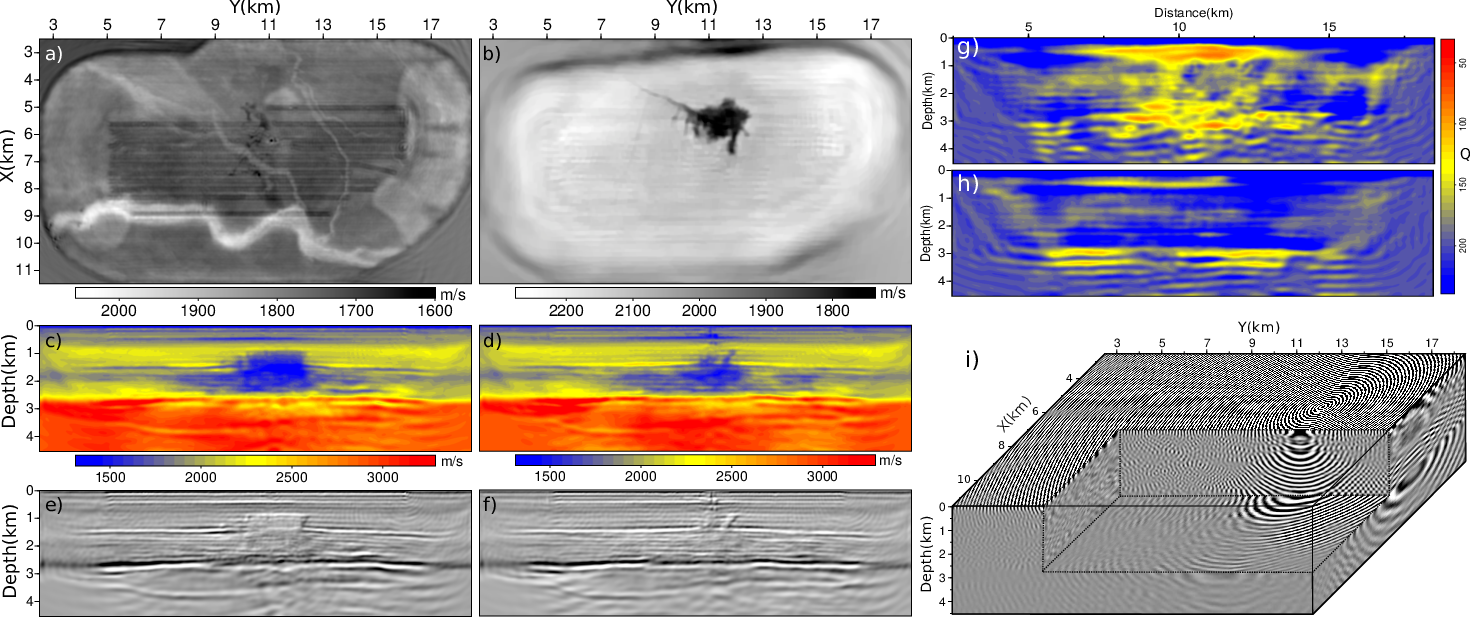
The three main issues raised by FWI are: (1) the nonlinearity of the inverse problem resulting from the oscillatory nature of waves. Mitigating this issue requires to design more convex distances or optimization strategies extending the linear regime of the inversion. The approach we are investigating is based on the so-called wavefield reconstruction inversion method where the inverse problem is solved with a relaxation of the wave equation generated by a feedback term to the observations. (2) Non uniqueness of the solution resulting from the incomplete illumination of the Earth's interior from the surface. This issue is classically mitigated by incorporating in the inversion some prior information coming from our knowledge of the subsurface, direct measurements from wells or empirical relationships relating parameters of different nature. We develop a general regularization library including nonsmooth (non differentiable) functions, which are implemented with proximity operators. (3) The computational burden of the numerical simulation of waves in 3D, which requires advanced skills in high-performance computing. We develop both seismic modelling engines in the time-space and frequency-space domains, which involve numerical problems of very different nature (evolution versus boundary-value problems). In the frequency domain, we use both sparse direct solvers such as MUMPS as well as hybrid solvers based on domain decomposition preconditioners. We also develop slope tomography, which jointly uses the slopes of locally coherent events and their traveltimes to improve resolution of the tomography and generate a better-posed problem. These models can be used as background or initial models for prestack depth migration or FWI. We are also interested in acquisition design, which should be cast as an optimization problem. This is an important issue for node surveys where the number of available instruments is limited and the acquisition footprint needs to be minimized.
|
|
Website: https://www.geoazur.fr/WIND
Fundings: consortium de compagnies pétrolières (Chevron, Shell, Total), 405k€ sur 3 ans
PI: Stéphane Operto (email: operto@geoazur.unice.fr; tel: 04 83 61 87 52); Hossein Aghamiry (email: aghamiry@geoazur.unice.fr)
Sponsors: Chevron, Shell, Total.
Academic collaborations: LJAD (UCA), LJLL (Sorbonne University), ENSEEIHT (Université de Toulouse), MUMPS-consortium, University of Tehran.
Dates : January 2020-December 2023